Satellite Imagery: What Resolution Fits the Bill?

Anastasiia Dolgaryeva
Delivery Manager
The big data revolution is in full swing, and satellite imagery providers lead the way. With their constellations orbiting the Earth, remote sensing data are now accessible to everyone. Given that satellite imagery processing technologies advance at a blistering pace too, this marks a new milestone for many industries – from construction and insurance to agriculture and forestry.
Planet, Sentinel, DigitalGlobe, and other spaceborne photography providers offer different resolution options, but how do you choose? Most importantly, how do you know if you need high-resolution satellite imagery data or a lower resolution will be enough? Keep reading to find out.
Satellite imagery applications across industries
Satellite constellations collect terabytes of information valuable to governments and commercial organizations alike. For example, these data can give you insights into how the crops are growing, where it’s going to storm, or how the landscape has changed over a certain period. You can leverage the power of satellite imagery for:
- Agriculture
- Urban development
- Construction
- Disaster mitigation
- Civil defense
- Water resource management
- GIS data acquisition
- Forestry
This is by no means a comprehensive list of the industries that use photos taken from space. As spaceborne photography and satellite imagery processing technologies advance, new applications appear like mushrooms in the rain. For instance, up until recently, volcanologists had very few instruments to predict volcanic eruptions. Now, however, they can benefit from satellite imagery analysis, too. It enables them to explore crater lakes and all the volcano-related changes to better forecast eruptions.
Remote sensing can also be used in the insurance industry. Insurers rely on it to expand their risk assessment techniques. Satellite imagery helps them determine the likelihood of natural disasters more accurately and calculate premiums accordingly.
Satellite imagery resolution: What it is and why it matters
Resolution refers to how easy it is to distinguish an object in a satellite image. In other words, it is the detail that each pixel covers. The smaller the pixel size, the more detailed the image.
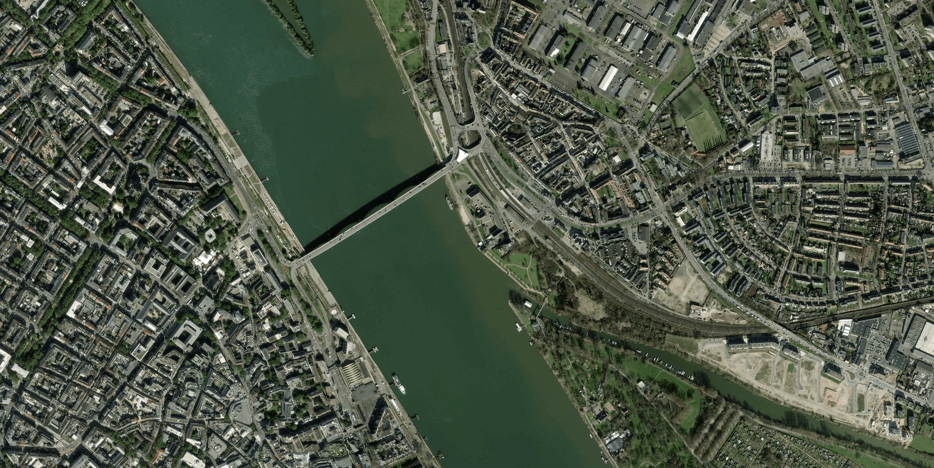
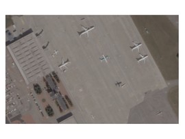
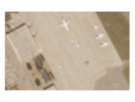
As of today, the finest resolution is provided by our partner – Planet satellites – SkySat with the resolution 30cm-50cm/pixel, PlanetScope – 3-5m/pixel. That means each pixel covers the objects that are 30cm-50cm high and wide and 3-5m, respectively. But these images can only be captured with high- to very high-resolution satellites and thus may be hard to get.
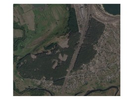
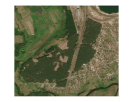
Low- and medium satellite imagery resolution is 60m per pixel and 10-30m/pixel, respectively. These images do not allow you to distinguish tiny details, yet they cover larger areas. Sentinel is among the providers of low- and medium-resolution imagery.
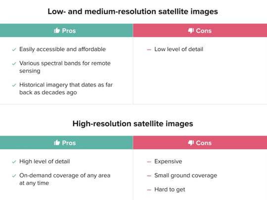
Of course, each resolution type has its pros and cons:

As you might guess from this satellite imagery resolution comparison, there’s no one-size-fits-all option. Low-res and high-res satellite images have different uses, and you should go for different resolution options depending on whether you need satellite imagery for a construction or meteorology project.
So, before you get out your wallet, consider this: What does your project call for? How accurate should images be? What spectral band do you need them to be delivered in? Read on to learn how you can best apply each resolution type.
High-resolution satellite imagery applications
Obviously, the higher the resolution, the more details you can detect in a satellite image. And although it’s going to cost you top dollar to get it, it’s often the only option to use. Despite covering smaller ground areas, high-resolution satellite imagery brings unmatched accuracy to the table.
You can’t go wrong with high-res satellite imagery if you’re involved in precision agriculture. Say you want to improve your canopy management. Not only are high-res satellite images helpful to keep a check on your vineyard, but you can also use them to calculate the leaf area index. By measuring it throughout the entire grapevine lifecycle, you can allocate water resources better and plan a harvest schedule.

Do your fruits or vegetables often fall victim to powdery mildew? With high-resolution satellite imagery data, you can identify vegetation pathogens and minimize yield loss. Whether these diseases are soil-borne or caused by off-site sources, you can detect anomalies as they occur.
High-res imagery can also be effective for farm livestock management. You can rely on it to observe animal migrations, monitor grazing livestock, and distinguish large species from the herd. Additionally, high-res satellite images can help reach the right population level at your farm by detecting abnormal animal patterns.
When it comes to forestry, high-resolution satellite imagery holds a special place in deforestation prevention. With illegal logging on the rise, it’s crucial to double down on sustainability efforts at the local and global scales. Over the last five years, we have lost 50 million hectares of our planet’s green lungs due to deforestation. However, high-res imagery is an excellent solution to monitor and prevent it.
High-resolution satellite imagery delivers pinpoint accuracy for calculating how many trees were cut down. They also allow you to manage carbon stocks, identify endangered species, and diagnose bark beetle attacks at their early stages. All these insights can help conserve a forest before it’s too late.
Other uses of high-res satellite imagery include:
- Soil erosion control
- Field boundary detection
- Natural anomaly mitigation
- Farm planning and field mapping
High-resolution satellite images are your best bet when there’s no room for deviation. But if you don’t need to zoom down to the smallest thing, other options are worth considering.
Medium-resolution satellite imagery applications
Medium-resolution satellite photos come with trade-offs – don’t expect to see objects the size of a town car. That doesn’t mean, however, that they are useless.
In fact, such images are a cost-efficient alternative to pricey high-res photography. Basically, you can go for them when you don’t need granular detail. That’s why medium-resolution satellite imagery would be most useful in projects that involve observing large territories.
For example, satellite imagery that has 10-30m/pixel resolution is just as insightful for clear-cut detection as they are for forest mapping. For instance, when analyzing degraded woodland areas, medium-resolution images can help make a rough estimate of biodiversity loss. That’s how you can prevent deforestation from spinning out of control.
For precision agriculture, medium-res data opens up numerous monitoring opportunities. Real-time observations can help you stay up-to-date with crop growth patterns to optimize fertilization and harvesting strategies. Besides, you can conduct medium-resolution satellite imagery analysis to assess the health of your arable fields. It’s probably the most versatile solution to measure soil nitrogen levels, moisture, and the damaging effects of pest infestations.
If you’re all set to carry out an urban expansion analysis, consider wrapping it up with medium-res images. They are a reliable data source on how urban areas change and what landscape transformations they trigger. Because Sentinel’s constellations offer a short revisit period, medium-res images can bring consistency to your analysis. They are accurate enough to zoom in on road construction projects, gas pipelines, and infrastructure changes that affect land use.
Medium-res satellite data can also benefit your project if you’re looking to:
- Watch out for the signs of agricultural pests
- Identify natural anomalies at the city and country levels
- Monitor water bodies to predict scarcity scenarios
- Share satellite data for news reporting
Though a bit coarse, medium-resolution satellite images provide quite detailed insights but on a larger scale. This makes them an optimal solution for agricultural projects, anomaly detection, and everything in between.
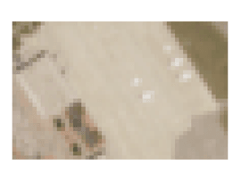
How can low-resolution satellite imagery be useful?
If you think low-resolution images are good for nothing, think again. Because these images offer multispectral satellite data, they can be of value for anomaly detection purposes. While higher-resolution images are more accurate, they can’t capture the details at a certain spectrum level.
Plus, a lower resolution means a lower price. It comes at the cost of coarseness, but you can still use low-res satellite images to:
- Detect large-scale natural anomalies – from melting glaciers to wildfires
- Monitor infrastructure changes at a regional or global level
- Substantiate trend mapping
- Take regression techniques to the next level when predicting crop yields
- Back-up crop growth modeling
Low-resolution satellite imagery can be your starting point. It’s up to you to harness it as a standalone data source or pair it with higher-resolution images.
The takeaway
Commercial satellite imagery and remote sensing technologies are invaluable tools to maximize agricultural resources and preserve natural ecosystems. It helps respond to environmental threats and address issues that are hard to detect with the naked eye.
Remote sensing works best when you combine medium-res and high-res images. You don’t always need super-close observations, and that’s when you can have the best of both worlds. Medium-res images are accurate enough to monitor large areas, like land changes and deforestation. But it is high-res satellite images that deliver profound insights. So, it pays to switch from mid-res data to get the bigger picture. Remember, it’s always a good idea to invest in higher resolution when minute detail can make the difference.
And if you still have questions about satellite imagery or need help with custom geo solutions, contact Quantum. We’ll be glad to help you out!
Geoanalytics
Turn satellite, drone, GPS, and other data into geoanalytics that identify when and where your greatest opportunities and risks are most likely to emerge.
Check the service