Reimagining agriculture with data analytics and ML

Michael Yushchuk
Head of Data Science
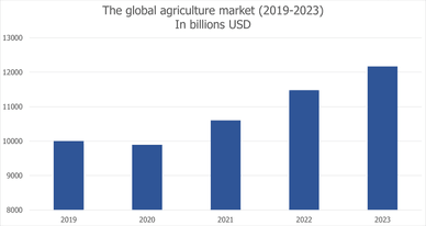
According to research, the global agriculture market is expected to grow 8% annually and reach $12 trillion in 2023. Due to this growth, the biggest challenges of the industry, like the world’s growing population, increasing urbanization, stressed usage of natural resources and global climate changes, need to be handled. And one of the ways to meet the demand for food is the widespread use of data-driven technologies.

In the last five years, data has significantly strengthened the position of precision farming, providing vital knowledge of where, how, and when to seed fields. Data analysis has become an indispensable source of knowledge about the current state of the fields, as well as allowing management of crops and predicting yield based on historical information. This is why it is now more important than ever to collect and maximize the value of agricultural data.
How data is being collected today
Today, the most common sources of farm data are satellite and drone imagery, IoT sensors in fields and agricultural vehicles such as tractors, seed drills, harvesters, fertilizers, etc. Let’s take a quick look at the most common data sources used in agricultural analytics.
Satellite and drone imagery
Satellite imagery can be used in a wide variety of scenarios such as remote monitoring of agricultural fields, tracking crop growth, determining field boundaries, identifying weeds, etc. Today, agritech startups and farmers use data from classic satellite constellations such as Sentinel. The advantages of Sentinel are that they provide data for free, and images are delivered in various bands, such as RGB or infrared. But Sentinel has some disadvantages, like poor image resolution, and low frequency of data updates – once every three to five days.
The next generation of satellites, such as Planet or DigitalGlobe, is handling the cons of the Sentinel, providing near real-time updates and high-resolution imagery. With the help of this data, it is possible to monitor, in detail, the state of the fields, build accurate thematic maps, and examine the health of the harvest. However, these solutions have their own cons: for farmers – the high cost of images, for developers – a small number of bands in raw imagery.

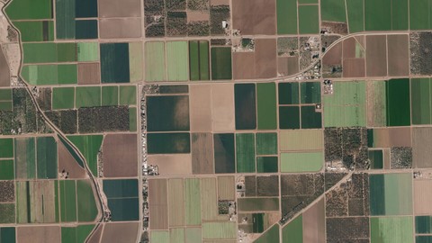
Besides, satellite imagery, in general, can be less useful if the field is covered by a cloud or a shadow is falling on it. To minimize these incidents, data scientists combine images from multiple sources, such as satellite and aerial imagery, to create an overall picture without interference. This is also known as hybrid imagery. Aerial photography is carried out using drones, airplanes, and even hot air balloons. Growers use drones most often because they provide high-resolution images at a low cost. However, it is not possible to launch drones every day, so the low frequency of imagery updates affects the accuracy of these kinds of solutions.
IoT sensors
Internet of Things devices have been used in agriculture for a long time. It all started with the rise of GPS technology in the early 90’s when the United States Air Force made available the positioning system for civil tasks. Since then, farmers have increasingly turned their attention to devices and sensors for agriculture, which were previously available only to the military or scientists.
There are already dozens of devices on the market that can be installed directly in fields. With their help, agronomists can receive up-to-date information about meteorological conditions, acidity, moisture, and soil composition. Other types of sensors can be installed on agricultural machinery to monitor tractors’ routes, control fuel, seed, and fertilizer consumption, as well as receive information about equipment wear.
The way machine learning and data analytics re-imagine agriculture
Data alone does not mean anything and will not help farmers in any way. It needs to be analyzed to make decisions here and now.
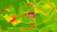
To handle that challenge, farmers use AI-powered agritech solutions to process raw data, analyze it, and extract value to increase business efficiency. Thus, computers enable the processing of satellite images and detect various events, such as boundaries of the field or the clusterization of weeds. This information can be used in a complex for more accurate field seeding and fertilization, as well as the fight against harmful plants that slow down the development of the crop.
Satellite imagery data is also a good source for different calculating tools. For example, the data can be used to create thematic field maps on which agronomists can clearly identify soil types, surface levels, and seeding history. This information allows farmers to decide which crops are best to plant, implement biodiversity and crop rotation policies, assess the use of crops and fertilizers, etc. With this information, farmers can affect the efficiency of growing crops, keep the soil from depletion and improve business performance. Also, satellite imagery allows the calculation of various agro-indices, such as NDVI, NDWI, NBR, etc.

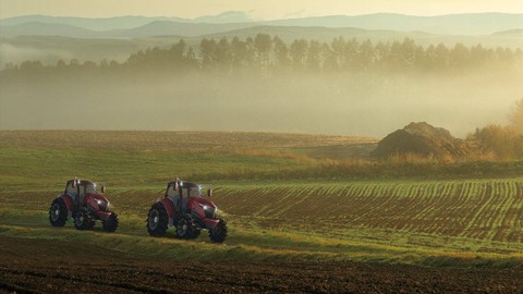
Using these solutions today, farmers create the foundation for future technologies. Thus, high-precision GIS (geographic information system) data will allow the use of autonomous tractors, seeders, fertilizers, and watering machines in fields, which will be controlled by various sensors, such as GPS, LiDAR, and cameras. This will avoid problems such as double seeding or skipping, for more efficient use of natural resources. For example, the Japanese company YANMAR showed the Robot Tractor, which is equipped with various sensors for orientation in the terrain, fully autonomous, and can be controlled from a mobile device.
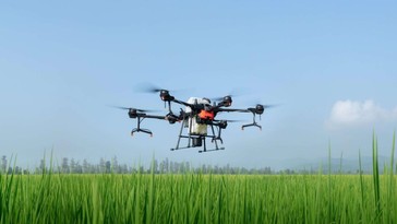
Advances in autonomous technologies will also enable drones to perform tasks such as remote planting, spot fertilization, caring for diseased plants, and weed control. For example, DJI is launching precision farming drones on the mass market that monitor agricultural fields and livestock. Some models of drones can carry loads of up to 20 kg, particularly for the precise spraying of the harvest.

With state-of-the-art satellites, it is possible to create instruments that will monitor plant growth in real time, determine their behavior, and identify diseased plants. The European Space Agency plans to develop its Copernicus program and launch, in 2021, two new satellites, which will complement the existing constellation. This will allow you to more precisely analyze fields and create more accurate instruments. Commercial groups are also planning to develop. Planet promises to expand its satellite fleet and provide photographic and video filming of the Earth’s surface in various spectra, for which clouds will not interfere with the analysis of the Earth’s surface.
Why agriculture is still struggling with old problems
The agritech industry has made tremendous progress over the past five years. The depth and breadth of the generated data, a variety of new sensors, more flexible software solutions, and significant improvements in the API that allow data transfer between systems – all this is already available to almost every farm. However, we still haven’t made much progress in basic data analysis, let alone harnessing the power of artificial intelligence. So why is this so?
Data fragmentation
In the agricultural domain, data is fragmented not only across all industry players but even within an organization, where precision farming data is stored in one system, sales data in another, and all this is not integrated into CRM. And so putting it all together is a real challenge. Moreover, the data collected from fields and farms are not standardized. There are no regulations or other prerequisites that would stimulate agribusiness to bring data to a single standard.
Lack of consensus
Farmers do not understand the value they can get from data analysis. For them, these technologies look too complicated and incomprehensible. But the market needs to change. Even such conservative businesses will have to adopt all this in the near future.
On the other hand, startups don’t understand all the problems of agribusiness. For example, you cannot apply the same approaches in Southeast Asia and North America. The way land is cultivated, soil fertilized, and the traditions of tillage, in general, are different. Since the approach varies from region to region, it should also be different technologically. This attitude will simply remove many products from the market that make technology for the sake of technology without deep domain expertise.
High prices
Yes, many of the existing solutions are expensive for most users. The validity of using sensors in the field is still a matter of controversy. On big farms, a lot of devices are needed, which means spending on their purchase, installation, and integration into the network. Also, in the field, they need to transmit the internet or equip all the sensors with cellular, which is expensive and not always possible. In addition, there is a high risk that the equipment will break down due to accidents with farm vehicles.
But this is temporary. As with any other technology, the more solutions that appear, the more accessible they will become to the end consumer. For now, farmers can combine different data analysis techniques and use cheap tools where possible and expensive ones where necessary.
Conclusion
Agricultural data analysis is already here. With it, farmers are already optimizing business processes, reducing costs, and increasing profits by taking advantage of the value of agricultural data. Unfortunately, for most farmers, modern technologies are still not available for various reasons.
Our mission is to make precision farming technologies available to more growers. Machine learning and data analysis can help achieve this goal and fulfill the most important one: to help farmers produce more affordable products to provide the growing population of our planet with quality food.
Read more: The power of AGI application in Agriculture
AI & Machine Learning
Automate repetitive visual monitoring to boost operational efficiency, reduce costly human error, and accelerate core business workflows.
Check the service